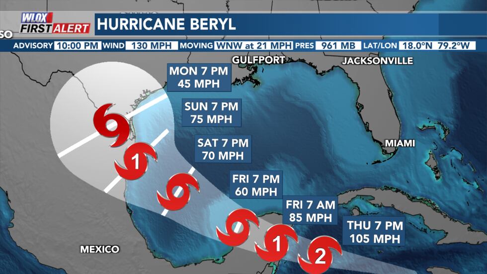
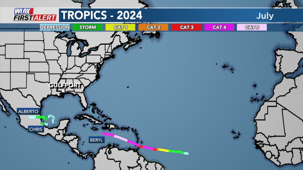
SOUTH MISSISSIPPI (WLOX) - The WLOX First Alert Weather Team is tracking Hurricane Beryl as it brings hurricane conditions to Jamaica tonight. Hurricane conditions are expected to reach the Cayman Islands by early Thursday and the Yucatan Peninsula Thursday night or early Friday morning.
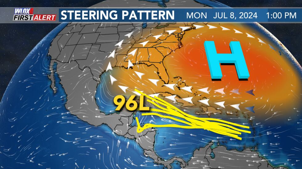
Meanwhile Invest 96L continues to track west behind Beryl and has a low chance for organizing into a tropical system over the next two to seven days.
There are no imminent threats to South Mississippi at this time.
Caribbean cruiser: where is Beryl headed?
After a stop near Jamaica, Beryl will continue cruising west towards the Cayman Islands and the Yucatan Peninsula.
Fluctuations in strength are likely along its track due to wind shear and interaction with land.
A landfall in Mexico’s Yucatan Peninsula is forecast by Friday, then is expected re-emerge over the southwestern Gulf (Bay of Campeche) by this weekend as a tropical storm.
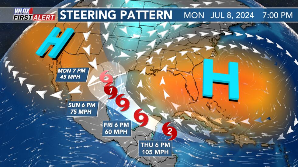
The same ridge of high pressure over South Mississippi that is causing excessive heat will be the same feature that steers Beryl west into the Bay of Campeche.
However, the ridge of high pressure is expected to break down and slide east as a trough digs in from the north around that time.
This could allow Beryl to curve north towards Mexico or the Texas coast.
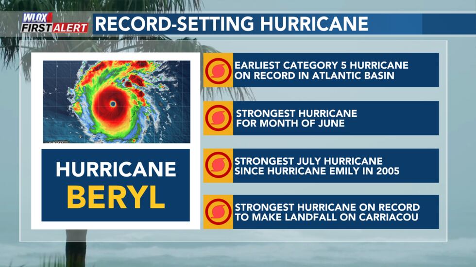
Hurricane Hunters flying through the center of the storm found winds sustained near 165 mph earlier this week, making it a category five storm. The storm has weakened since.
Beryl is the earliest category five hurricane on record, beating the old record set over two weeks later by Hurricane Emily on July 17, 2005. In addition, Beryl now holds the record for strongest July hurricane by wind speed, also beating Hurricane Emily which had maximum sustained winds of 160 mph. Beryl also holds the record for the strongest June hurricane.
Beryl made landfall Monday morning on Carriacou Island, an island of Grenada, as a category four hurricane with maximum sustained winds near the center of 150 mph - the strongest Hurricane to make landfall on the island.
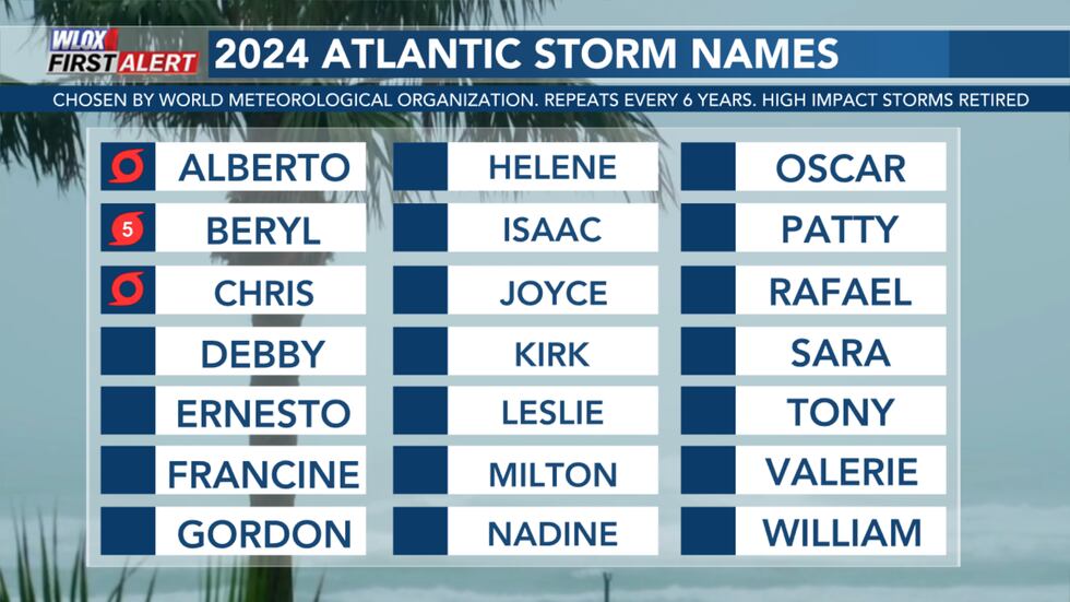
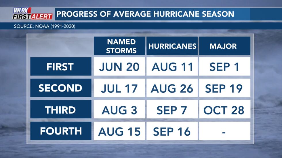
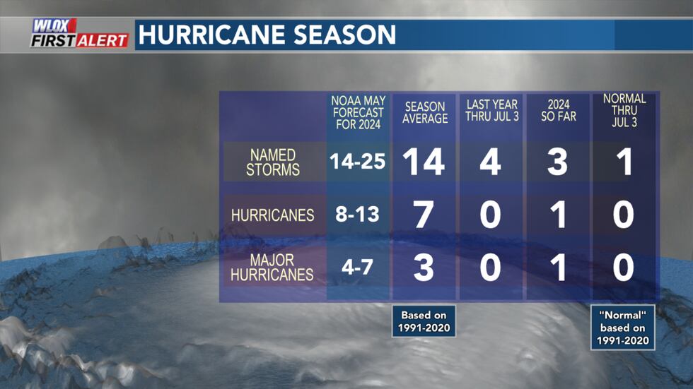
Beryl is the first hurricane of the 2024 Atlantic hurricane season and formed about 6 weeks before the first hurricane typically forms in the Atlantic. It also became a major hurricane about two months before the first major hurricane typically forms - which is around September 1.
Tropical Storm Chris formed briefly on June 30th and dissipated after making landfall north of Veracruz, Mexico. Typically, the third named storm of the season does not occur until about August 3.
Tropical wave Invest 96L could become a depression or tropical storm in the coming days as it heads west through the Caribbean behind Beryl. The wave is expected to be in the western Caribbean by the end of this weekend as it is steered by a ridge of high pressure to the north.
Early indications are that 96L may struggle to develop as it is influenced by wind shear caused by the outflow from Hurricane Beryl.
However, conditions may become more favorable once 96L reaches the western Caribbean. Some models continue to track 96L towards the southern or southwestern Gulf of Mexico early next week.
It is too soon to say exactly where 96L will track or how organized it will become. Keep checking back in for updates.
The next available name on the list is Debby.
See a spelling or grammar error in this story? Report it to our team HERE.
Copyright 2024 WLOX. All rights reserved.
"behind" - Google News
July 04, 2024 at 08:54AM
https://ift.tt/1DiktN5
Beryl to reach southwest Gulf this weekend, tracking Invest 96L behind it - WLOX
"behind" - Google News
https://ift.tt/j2CUkmH
https://ift.tt/hJbg8Am
Bagikan Berita Ini


0 Response to "Beryl to reach southwest Gulf this weekend, tracking Invest 96L behind it - WLOX"
Post a Comment